
Who knew science was a universal language? Over the past few years the UK Department of Environmental and Earth Science is expanding its reach internationally, working with their geological compatriots in Europe, Africa, Australia, Asia and South America to advance science and advance goodwill.
India
If you’ve ever been camping, you may have personal and painful experience with the dangers of drinking surface water from lakes, rivers and ponds. For many people in the world, that is their only source of drinking water and childhood diarrhea is one of the major causes of death worldwide.
For the whole of his academic career, Alan Fryar has studied the geological aspects of water quality. What controls that chemistry in terms of geologic processes? What is the chemistry of groundwater? Are there human factors involved such as overuse of fertilizers or improper waste disposal?
Most of these projects kept him close to home, but then a graduate student from Calcutta arrived at his lab with a desire to pursue a project very near to his heart.
In the early 1970s in the Ganges Delta in India, there was a movement spearheaded by UNICEF to put in 100,000s of wells to pump ground water to avoid problems caused by drinking surface water. Sediments such as clay and sand tend to strain out microorganisms like a natural water treatment plant, making groundwater safer to drink than surface water. Thus, from a public health perspective, the wells had a profound, positive effect on community wellbeing.
“Unfortunately, no one thought to test the wells for arsenic,” Fryar said grimly. Arsenic is a chronic pollutant so it took decades for the problem to be discovered.
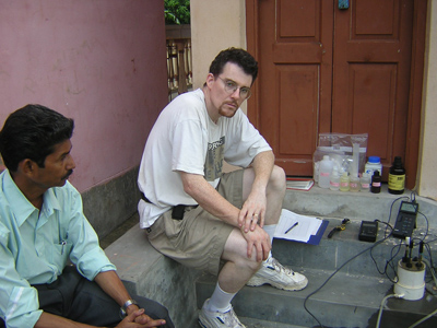
“In the 1990s it was noted that people began showing up with skin lesions, which in some instances turned into cancer and was diagnosed as arsenic poisoning,” Fryar continued. “People went back and tested the wells and found naturally occurring arsenic contamination of the ground water was pervasive throughout the region.”
An epidemiologist at University of California, Berkeley called it “…the largest mass poisoning in human history.”
“One of the challenges now is, can we purify the water in economical and sustainable ways?” said Fryar.
Fryar and his former student Abhijit Mukherjee have been working with public health officials in India to aid them in finding a solution. Until an answer is found, the people in the area have to make an extremely unfortunate choice.
“It may be a question of what could kill you, such as low arsenic concentrations, versus what can kill you, such as bacteria and microorganisms,” said Fryar.
“It’s a Hobbesian dilemma.”
Egypt and Italy
When you want to know which way north is, you use a compass. The compass needle tracks the magnetic north pole to point the way.
Rather than looking for a longitudinal direction, Dhananjay Ravat instead looks for geothermally active places under the Earth’s crust that can be used for geothermal energy plants. And while he also uses the earth’s magnetic field to find what he is looking for, his compass is a little more complex than the type a Boy Scott might carry.
“Geology is inherently global,” declared Ravat. “There are a number of geological phenomenon that work universally, but we have to go seek out examples from different parts of the world. It is driven by two things: we’re always trying to figure out interesting geological features and interesting geological formations. It is also driven by economic and resource exploration.”
In a world where our traditional energy sources are finite and being depleted every day, geothermal energy is one hope for a more sustainable energy source and many countries are exploring their options.
Enter Ravat.
To more effectively find the “warm places” deep in the earth’s crust that can be used for geothermal energy, Ravat is working with researchers in Italy, Egypt and Australia to develop location techniques using the earth’s magnetic field.
“The magnetism in the rocks is controlled by temperature,” Ravat explained. “If you exceed a certain temperature then the magnetism vanishes. Only when the rocks are cooler than that temperature can they be spontaneously magnetized.”
Using that principle, called the Curie Temperature or Curie Point, to pin down temperatures deep in the earth’s crust, researchers can determine optimal locations for geothermal energy plants.
In Italy, Ravat and his Italian collaborators have applied these magnetic methods and discovered hot magma chambers under a series of moderately dormant volcanoes near Sicily. He is also duplicating this work in Egypt and has hosted scientists from Egypt on a state department National Science Foundation funded collaborative grant.
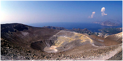
“Not all areas of the world are hot enough to provide enough heat to produce energy,” Ravat explained. “One reason people thought eastern Egypt was worth looking into is because this is the region where the continents started to split some 30-40 million years ago and it’s reasonable to expect to find hot rocks close to the surface from the added influx of heat from the mantle and sea floor spreading.”
While Italy and Egypt are hardly the first countries to locate prime areas for geothermal energy plants, the methods are unique. It’s fairly obvious when a particular location is near a “hot area” of the crust if a hot spring is sitting on top of it. Ravat and his colleagues instead use magnetic surveys to discover locations that may not have surface evidence of being, literally, a “hot spot.”
And once again a magnet points the way.
Norway
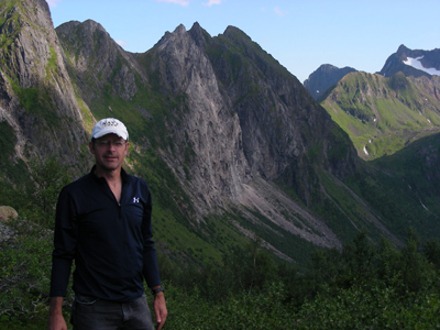
The shelves in David Moecher’s office are packed with rocks. Big rocks. Little rocks. All grouped near a microscope. Moecher studies the evolution of mountain belts within a geological field called tectonics.
“The Earth is our laboratory. We’ve got to go outside to do our experiments. I have to go to Norway to collect these samples. It’s a tough job but someone has to do it,” Moecher grinned.
“Scientifically, Norway is an incredible place to work. I’ve worked on both sides of the Appalachians now and, in my opinion, Norway got all the good rocks!”
Moecher’s shows off one particular grey Norwegian rock with black veins injected into it.
 “The only way you can get temperatures high enough to melt a rock is when a fault slips as fast as an earthquake would slip,” Moecher said, explaining how the rock came to be. “An earthquake slips about 1-2 meters per second – or a fast walk – and every time that slip happens in the crust the stresses are so high you literally melt the rock.”
The earthquake that created this particular rock is estimated to have occurred about 400 million years ago. By the time of the last Ice Age, the crust had eroded down exposing a fault that was once buried 10 to 15 kilometers below the surface of the Earth.
So what can a 400-year-old earthquake tell us today?
“Earthquakes presumably haven’t changed their mechanism over time,” said Moecher. “Looking at the earthquake source, it wouldn’t matter if we were to drill into the San Andreas Fault now or if we were to be able to see the San Andreas 50 million years from now. We look at older fault zones to infer what is happening within the deeper parts of active fault zones today.”
Moecher’s work in Norway grew organically from a series of professional connections. He and his national and international collaborators have gleaned data such as, the pressure and depth of the fault when it slipped. Through geologic mapping, they have also discovered a more nuanced picture of what a fault zone actually looks like.
“If you look at the particular fault zones where these rocks form, they tend to branch and rejoin, they are kilometers wide, and they are very different than what we think a fault zone looks like based on what the seismologists think it looks like,” Moecher explained.
And if these rocks look sort of familiar, it’s because they are. “Norway is just a continuation of the Appalachians basically,” said Moecher.
It’s geology without borders.
China
Ed Woolery is also “into” earthquakes; namely the ones that might happen. While at an international earthquake conference six years ago, scientists from UK and the Lanzhou Seismological Institute and China Earthquake Administration discovered they were working on similar fundamental seismological questions, but in different parts of the world.
Both research teams were studying the locations of active geologic faults capable of producing large earthquakes, attempting to determine how large the earthquake could be for a given area, and how often it might occur.
Since discovering each other, the UK Department of Environmental and Earth Sciences has hosted three visiting scholars from China and plans to send their first graduate student to the Gansu Province this summer to perform active seismic fieldwork for his thesis.
Woolery and his UK team have greatly benefited from the thorough historical records of earthquakes in China. While earthquake records in the central United States go back less than 200 years, the Chinese largely complete and comprehensive historical record is goes back nearly 2,000 years.
Similarly, through this collaboration the Chinese can benefit from the historical experience of the United States as they expand their industrial infrastructure in earthquake-prone zones.
“As we have seen from the recent events in Haiti and Chile, earthquakes centered in or near urban areas can have catastrophic societal consequences when infrastructure has not been adequately designed to resist,” said Woolery.
“The Chinese government recognizes this problem but getting the proper regulations in place and ahead of the rapidly expanding industrial development remains a challenge. The U.S. faced similar problems several decades ago, so we are able to share not only the general experiences, but some of the unanticipated ‘lessons learned’ with our Chinese colleagues.”
Going forward, there are some exciting new avenues of research on how earthquake ground motions are different depending on the geological conditions. Through his work in China, Woolery has made contacts with other Chinese provinces that are also interested in collaborating on this research.
Through it all, Woolery has been struck by the ways science can bring us together.
“I’ve been reminded that scientific inquiry is the same regardless of differences in culture, geography, or form of government,” said Woolery. “The scientific method is a universally recognized common place of understanding.”