
By Madison Dyment
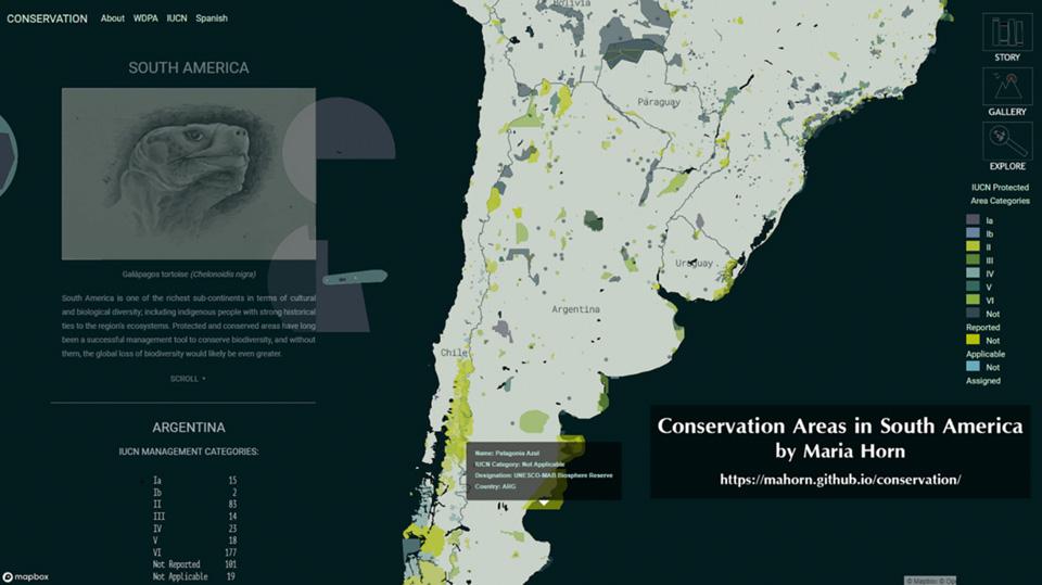 LEXINGTON, Ky. --- Maria Horn, a master’s student in the UK's College of Arts and Science’s Geography Department’s New Maps Plus digital mapping graduate program, recently was awarded the top prize in the NACIS Student Dynamic Maps Competition for her digital map “Conservation Areas in South America.” The competition is a national-level contest for students in the field of dynamic mapping in cartography. Horn is the second consecutive student from the UK Geography Department to win the prize.
Horn, a native of Bolivia, received a bachelor’s degree in biology from Gabriel Rene Moreno University in Santa Cruz. She moved to the United States after getting married in 2006. Because she needed to learn English, Horn began to work so she could improve her language skills.
“I started working in a restaurant and then began working at the University of Kentucky,” Horn said. “I served in a couple of clerical jobs at UK and then moved to my current position as a language interpreter at the university.”
Through the encouragement of her husband, who works in the Geographic Information System industry, Horn formed an interested in the field and became aware of UK’s digital mapping program. Horn, a member of the first cohort of students in the New Maps Plus digital mapping program, began her certificate program in 2015 and completed her master’s degree in the 2018-2019 term. After she took a few years off, Horn returned to complete advanced-level graduate courses in the program.
Horn’s instructor in the program -- Richard Donohue, assistant professor in geography -- suggested that she enter the competition. Horn credits Donohue for giving her invaluable assistance along the way. Horn entered the map she had created for her final project, a requirement to receive her master’s degree. Her winning map reflects her personal interest in conservation and her Bolivian heritage.
“As a biologist, conservation is very important to me, especially concerning Bolivia, which is one of the richest countries in biodiversity,” Horn said. “I chose to create a map that shows all of the conservation areas in South America.”
The map is divided into three sections. The first displays each country’s conservation areas with the option to zoom closer. The second shows UNESCO biosphere reserves, including descriptions and photographs. The third section displays the respective categories of all areas.
“Maria’s map was an ambitious project in several ways,” Donohue said. “Maria’s map was both narrative and interactive and allowed users to scroll through the page as the interface guides them through the experience of the story.”
Donohue also credits Horn’s map with allowing users to pause along the way, use different filter options, load additional datasets and retrieve specific details from the map’s interface.
“Maria, being a native of Bolivia, additionally made the map bilingual, giving the option to switch back and forth between an English and Spanish version,” Donohue said. “To my knowledge, it’s the first fully bilingual map coming out of our program and the first to win such a prize as the NACIS competition.”
Donohue also praised Horn’s talents as a student and cartographic designer.
“Maria is a terrific visual designer,” Donohue said. “She has a natural ability to choose appropriate colors and fonts, has an excellent sense of visual hierarchy and fearlessly breaks from conventional, safe solutions. She is proud and independent and is a unique case of a cartographer who is strong in both the visual design and technical solutions.”
Despite this high praise, Horn was blindsided by her achievement.
“I didn’t expect to win,” Horn said. “I opened the email early in the morning when no one was awake, so I woke my husband up with a big grin. He went and got me flowers that day!”
Horn received a certificate for her accomplishment and a $500 prize.
“We’re so excited for Maria’s accomplishment and also for future students of the digital mapping program,” Donohue said. “It’s an exciting field and we’re grateful for the support from UK, the College of Arts and Sciences and the Geography Department to facilitate the opportunity.”
Horn hopes to find a position where she may continue to develop the skills she has learned through the program.
By offering a curriculum combining traditional values of cartographic education and cutting-edge web design techniques and mapping solutions, the program is a challenging and supportive environment for students to learn skills and concepts.
“We want everyone to succeed, and sometimes this requires dedicating extra time to individual student needs,” Donohue said. “It’s been a tremendous amount of work for both instructors and students, but it’s paying off.”
The University of Kentucky is increasingly the first choice for students, faculty and staff to pursue their passions and their professional goals. In the last two years, Forbes has named UK among the best employers for diversity, and INSIGHT into Diversity recognized us as a Diversity Champion three years running. UK is ranked among the top 30 campuses in the nation for LGBTQ* inclusion and safety. UK has been judged a “Great College to Work for" two years in a row, and UK is among only 22 universities in the country on Forbes' list of "America's Best Employers." We are ranked among the top 10 percent of public institutions for research expenditures — a tangible symbol of our breadth and depth as a university focused on discovery that changes lives and communities. And our patients know and appreciate the fact that UK HealthCare has been named the state’s top hospital for four straight years. Accolades and honors are great. But they are more important for what they represent: the idea that creating a community of belonging and commitment to excellence is how we honor our mission to be not simply the University of Kentucky, but the University for Kentucky.